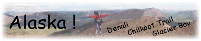
The
Travelogues of Diane and Dave
|
The
Travelogues of Diane and Dave
|
|||
|
|
|
|
|
|
|
|
Our Alaska vacation started with our arrival in Fairbanks,
the second largest city in Alaska. On final approach going into the airport
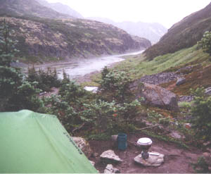
I'm looking out the window to see the city After spending a few days in the "big" city with Karen, Diane and I took a 2 day trip down to Denali Nat. Park. We took the camper shuttle bus to Wonder Lake Campground. It is located at the end of the 85 mile park road. A 5 hour ride in a school bus on a dirt road. We had a beautiful unrestricted view of the Alaska Range from the front door of the tent. Hidden somewhere in the clouds was Denali (aka: Mt. McKinley). At about 10 PM the clouds started to thin out. By 11 PM the clouds had totally disappeared and there was Denali out in all its naked glory shining and glistening in the golden Alaska sunshine. (Yes, it was still sunny at 11 PM. In fact it was still sunny till about 1 or 2 AM.) Before the clouds cleared, all I could see were the 12,000 foot high foothills. Then after the clouds cleared there was Denali twice as high at 20,300 feet. Even from a distance of 26 miles the size of the mountain (compared with the others around it) is totally awesome! (By the way, Denali is native American for "the Great One"). We didn't want to go to sleep. We just wanted to sit there and watch it.
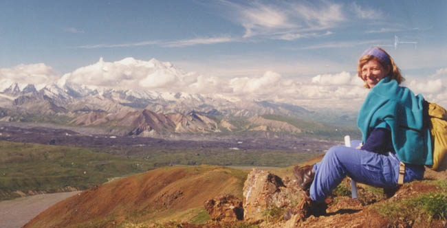
Denali and a Caribou from the Wonder Lake Campground area Unfortunately, the mosquitoes are horrendous at Wonder Lake. Many people (us included) wore headnets to keep the bugs out of their faces. You didn't dare bare any flesh. They'd still try to bite thru your clothes. The next morning Denali was still out. By about 8 AM it was starting to cloud over, but by then it was time to take the shuttle bus back out. We got off at Eilson Visitor Center (about 1/2 way back) and did a day hike up on a ridge.
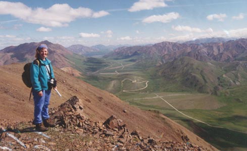
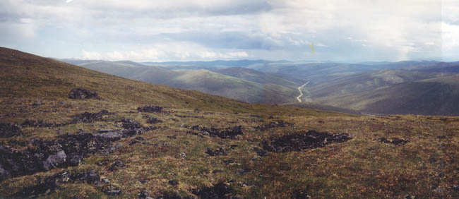
While hiking along the ridge we saw gobs of wildflowers and Caribou. On the original bus trip into the park we saw several Caribou, Moose, Dall Sheep and Grizzlies. We had one Grizzly cross the road about 50 feet in front of our bus. After Denali we drove back to Fairbanks. From Fairbanks we took a two day drive out to Circle and Circle Hot Springs. It was about a 3 hour drive on the Steese Highway (another dirt/gravel road). Along the way we stopped and did a short hike along the White Mountain Trail in the Pinnell Mts. As you can see in the photo, the mountains are not forested, but instead covered with very short scrubby growth.
A view eastward from the White Mountain Trail in the Pinnell Mts. You can see Steese Highway leading eastward towards Circle, Alaska. After our short diversion we continued on to the resort at Circle Hot Springs. The "resort" out there (built in 1930) has an outdoor swimming pool which is fed by hot springs. The pool temperature is about 100 deg F. It is supposed to be a great place to go in the winter when the air temp is about -40 F. We were told it is very exhilarating to run from the bath house to the water and back in the sub-freezing air. In winter time the steam cloud from the pool can be seen for miles. While out there we continued on to the "town" of Circle. It consisted of 2 general stores, a dirt airfield, a phone booth and the Yukon River. We took pictures standing in front of the Yukon River. A few days later we left Fairbanks and took a 7 hour drive down to Anchorage. We stopped off at the town of Talkeetna. It's claim to fame is that it is the starting point for all ascents of Mt. McKinley. We stayed at the Talkeetna Roadhouse (built 1917), a small dive of a historic motel with the bath "down the hall". They have autographed photos and flags from most of the Mt. McKinley climbers hanging on their restaurant walls.
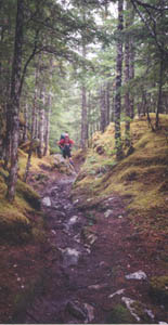
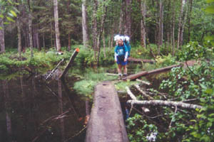
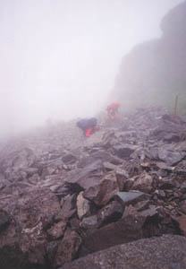
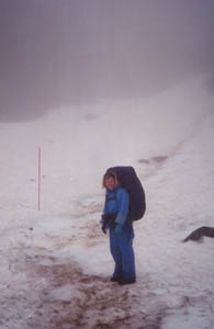
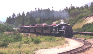
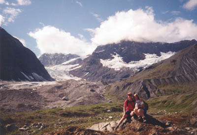
The next day we took a 9 mile hikers shuttle to Dyea and started our backpack trip on the Chilkoot Trail. The first 2 days were foggy, misty and drizzly while the second two days were nice and sunny. The best part of the trip was the second day when we went over the 3,000 foot summit of the pass.It was a rock hoppers heaven/hell. It was gobs of fun carrying a 45# pack up a 45 degree slope clambering up and over boulder sized rocksup the hill. Sometimes the trail led over snow packs or thru very wide shallow streams (run off from nearby glaciers and snowpacks). The terrain was varied, challenging and beautiful. It was 33 miles from Dyea to the end of the trail at Lake Bennett. At Lake Bennett we took the historic White Pass and Yukon Route steam train back down the mountain thru the White Pass to Skagway. We spent the night in the Golden North Hotel again. After the hike we were tired, hungry (make that starving after 4 days of freeze-dry and oatmeal) and cranky and we were dying to take hot showers. Only this evening the hotel hot water system wasn't working. The hotel receptionist drove us in the hotel van to the edge of town where we could get hot showers in the restrooms of a local RV park.
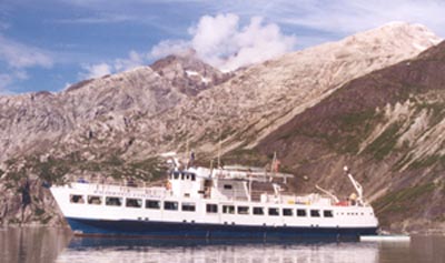
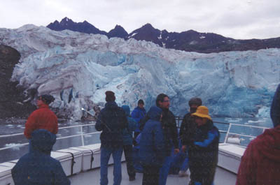
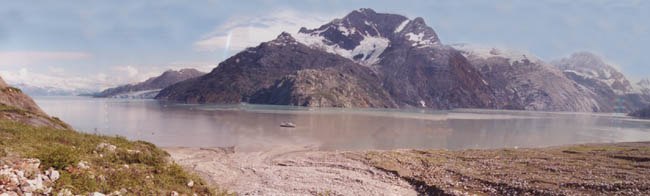
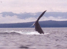
We spent the day after the backpack doing laundry, vegging-out and trinket shopping in Skagway. Since it had been very foggy and misty at the summit we found a pilot who would take us on a custom flightseeing ride along the Chilkoot Trail from beginning to end. It was fascinating to see the mountains and the pass and the trail and the campgrounds from the air. What had taken us 4 hard days of hiking, we covered in less than an hour round trip! The next day we flew back to Juneau and then to Gustavos where we boarded our cruise ship in front of Glacier Lodge in Glacier Bay National Park. The ship was about 100 feet long and carried about 33 passengers. They took us all over Glacier Bay. We "parked" in front of Johns Hopkins Glacier for about 3 hours at a distance of about .3 miles. I was amazed at how much noise a glacier makes. It made noises like low rumbling distant thunder and sometimes like sharp rifle shots. Every now and then part of the face of the glacier would fall off into the sea. Twice we went sea kayaking in the bays amongst the icebergs and whales. Twice we went ashore for short hikes. While on the ship in the National Park boundaries we had a National Park Ranger on board. She was great pointing out all the sea birds, sea lions and other points of interest. I felt like I was on a Jacque Costoue [sp.] expedition. Outside the park we watched humpback whales "frolicking" in the sea. After our 3 day tour the ship dropped us off in Juneau.
The next day we toured Juneau and did a short 8 mile hike alongside Mendenhall Glacier. Then it was on to Seattle and then Portland where we visited Diane's sister Kathy. The first day we checked out the Columbia River Gorge area (nothing exciting at all) and the second day we drove along the Oregon coast. Oregon has lots of beautiful State Parks along the coast with beautiful beaches. Oregon has a beautiful sea coast! After Portland it was back to Baltimore and the daily grind of "back to work".
A whale at Glacier Bay waves goodbye with his tail ! |
|
|
|
last revised
:
February 12, 2006
|
 and
there is nothing to see. Just wilderness as far as my eyes could see.
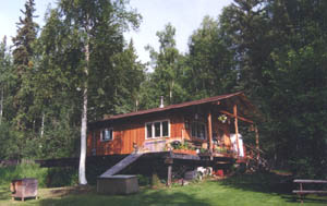
Diane's friend Karen picked us up and took us to her house out in the"suburbs".
She has a beautiful, gorgeous wood cabin out in the woods at the end of
several dirt/gravel roads.It was like a single family one bedroom apartment.
She has moose in her yard some mornings. The next day we went into the
"city". It was about as big as Laurel! The city streets are
paved. All the outlying suburbs are dirt/gravel roads. I was in true he-man
heaven driving Karen's 4x4 stick-shift pickup truck on dirt roads out
in the "wilds" of Alaska to go to the local redneck general
store to pick up orange juice and charcoal briquettes.
and
there is nothing to see. Just wilderness as far as my eyes could see.
Diane's friend Karen picked us up and took us to her house out in the"suburbs".
She has a beautiful, gorgeous wood cabin out in the woods at the end of
several dirt/gravel roads.It was like a single family one bedroom apartment.
She has moose in her yard some mornings. The next day we went into the
"city". It was about as big as Laurel! The city streets are
paved. All the outlying suburbs are dirt/gravel roads. I was in true he-man
heaven driving Karen's 4x4 stick-shift pickup truck on dirt roads out
in the "wilds" of Alaska to go to the local redneck general
store to pick up orange juice and charcoal briquettes. 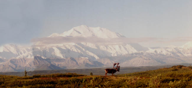
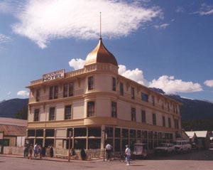 From
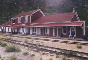
Anchorage we flew to Juneau and then the next day on to Skagway. While
in Skagway we stayed at the Golden North Hotel, the oldest operating hotel
in Alaska (shown to the right). Our bath was again "down the hall".
The hotel was decorated like it was back in the early 1900's. The rooms
were all filled with antique furniture and antique fixtures.
From
Anchorage we flew to Juneau and then the next day on to Skagway. While
in Skagway we stayed at the Golden North Hotel, the oldest operating hotel
in Alaska (shown to the right). Our bath was again "down the hall".
The hotel was decorated like it was back in the early 1900's. The rooms
were all filled with antique furniture and antique fixtures.