|
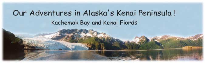
Day 10 - We had a special day hike planned
for today. Since Karen was still with us, we decided to hike to the top
of the Exit Glacier and view the Harding Icefield beyond. It was a hike
of about 4.0 miles up and then 4.0 miles back down. The trail starts near
the toe of the glacier and immediately starts ascending thru woods.
Along the way are many wildlife viewing opportunities. We saw a mother
moose and a calf foraging in the bushes just 20 feet off the trail. While
the mother nonchalantly munched away, the calf seemed more interested
in watching us humans watching them. According to the trail register,
some other folks saw a mother bear and its calf along the trail. We missed
the two of them but we did get to watch a bear walk across the glacier
and then up and over the mountain on the other side.
|
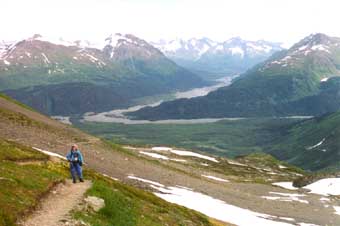
After awhile the trail leaves the tree-line and enters an alpine-like
area . The alpine area then quickly petered out and we were hiking
on scree and snow patches. At times it was a little hard following
the trail over the scree sections. On the snow patches, you'd have
to look for the dirty ruts in the snow made by previous hikers.
The trail ended with a (approx.) ¼ mile loop. Just before
the start of the loop is a small shelter/hut. It would be useful
if a sudden storm came up. While we were up there the sky was totally
overcast, making for boring photos. I had been hoping for clear
blue skies! :-(
|
|
|
|
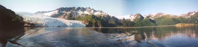
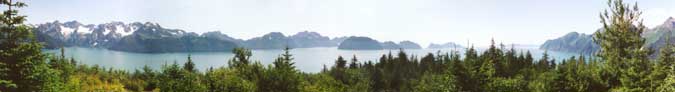
Here's a 360 degree panoramic from the top of the trail.
Click on the photo for an enlarged view (101k).
|
We spent about an hour sitting on the rocks and taking in the wide, white
expanse of the Harding Icefield. According to the brochure it covered
300 square miles. Karen had to leave us early to return to Anchorage for
a dinner engagement, but we stayed a little longer. We eventually took
a leisurely pace back down the mountain and at the bottom joined up with
all the regular tourists, the ones in the multicolored Bermuda shorts
with black socks and shoes that would never dream of walking off the flat,
paved, ½ mile tourist path that circled around the toe of the glacier.
If they only knew the fantastic views they were missing up at the top
of the mountain.
Looking back up where we had been, I noticed that the sky had cleared
up! D*** ! Why couldn't it have cleared while we were up there! I was
almost tempted to hike back up, but I knew the 3.5 mile hike would take
about 2 hours, I was tired, it was nearly the end of the day, I was hungry
for supper, and I just knew it would probably cloud over again by the
time I reached the top. I still hold a grudge against Mother Nature for
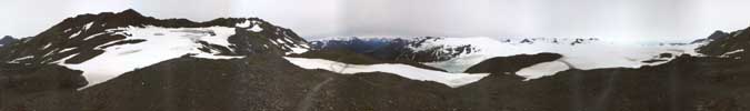
the clouds that day. :-) On the way out along the access road, I took
the shot below of Exit Glacier "pouring" out from between two
mountains.
Day 11 - Our planned activity today was
a cruise thru Kenai Fiords National Park with Kenai Fiords Tours. The
cruise didn't start till about 2:00, so we had plenty of time to get up
and have a leisurely breakfast, walk around the town of Seward and shop
for trinkets at the local tourist souvenir shops.
The cruise was great, it was one of the highlights of our vacation. Kenai
Fiords Tours offers several different trips. We chose the 6 hr cruise
with an onboard dinner. While the dinner was not gourmet restaurant quality,
it was very good. It was a salmon dinner, with veggies and as much dessert
as you could eat. The cruise took us out to the end of Resurrection Bay
and then back into Aialik Bay. Along the way the ship's captain would
slow down every time whales were sighted, he would pull up close alongside
rocky cliffs so we could see the Puffins perched on the rocks, and he
parked at the end of Aialik glacier, a tide water glacier, so we could
listen to the glacier and watch sections of the face calve off. The highlight
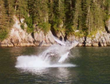
of the trip was when a humpback whale breached alongside the ship right
in front of everyone!
|
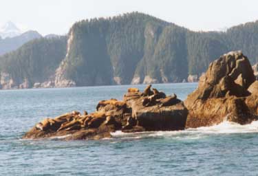
(top right) We cruised past some rocks where a group of sea
lions were basking in the sun.
(bottom right) One of the trip highlights! A humpback whale breached
right alongside the ship. I was very lucky that my camera was ready
and I was fast enough to capture him!
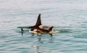
(below) Three orca whales swimming together in a close "pod"
while they "sleep".
|
|
|
|
|
| |
|
|
This is Aialik Glacier at the end of Aialik Bay. We "parked"
right in front of the glacier for about a half hour
listening to it and watching pieces calve off the front face.
|
Day 12 - This morning we had to get up early,
drive thru the town of Seward and head out to Miller's Landing. We had
arranged for them to ferry us out to Caine's Head State Park. There's
the ruins of the old WWII Army Fort McGilvray at the state park high on
a cliff overlooking Resurrection Bay. There are only three ways to get
to the old fort. The first is to hike 4.5 miles along the shore. The only
problem with this method is that you have to time your hike out and back
to coincide with low tides as the trail goes along the beach and floods
during high tide. The second method is to rent kayaks and paddle out.
The third method (the method we chose) is to arrange a water taxi. The
problem with the water taxi is that you are committed to going out and
returning on their schedule. All three methods drop you off at North Beach,
the location for the trailhead to the fort.
|
|
|
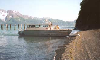
The folks at Miller's Landing offer a
first class water taxi service.
|
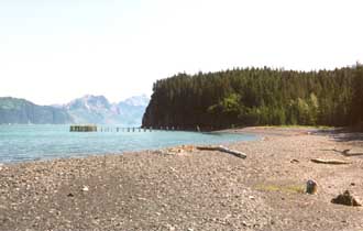
Here's North Beach showing the old
army dock ruins.
|
The hike up to the fort is an easy gentle uphill walk of only 2.0 miles.
All that's left of the fort is a small maze of underground concrete bunkers.
You can freely wander about the underground rooms, just make sure you
bring a good strong flashlight as it's pitch black inside. Our mini-mag
penlights were woefully inadequate! All the rooms are totally empty. There's
a map of the place outside at the front entrance, study and memorize it
so you have an idea of what you're looking at inside. The ruins are damp
and dirty, and there are occasionally open pits in the floor so keep your
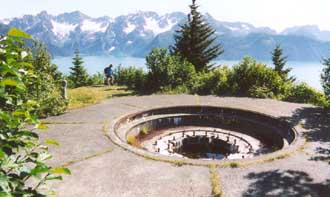
eyes open and be careful exploring. There are two large concrete pads
outside where 6 inch cannons were mounted. They are long gone. On top
of the earthen mound that covers the fort, is a small camouflaged "pill
box" that was used by the spotters who aimed the cannons. You get
a great view of Resurrection Bay from the site of the old cannon emplacements.
|
|
This is a wide angle shot showing Resurrection Bay from the
top of the fort. Seward is to the left.
|
|
|
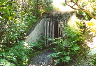
(top left) The front door to the fort. The inside of the concrete
fort is wet and dirty and dark. Bring strong flashlights! In true
US gov't fashion, it was abandoned right after its completion!
(bottom left) The remains of one of the two cannon emplacements.
You get a great view from up here.
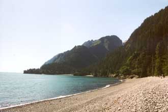
(Bottom right) South Beach at Caine's Head. Not quite as warm
as Miami's South Beach, but certainly more natural beauty. A lovely
spot for a secluded lunch.
|
|
|
|
After you leave the fort, you can hike to South Beach. South Beach is
where the Army barracks were for the personnel manning the fort. The 2.5
mile walk was a gentle downhill. Just before you reach the beach there
are some old ruins of the barracks right alongside the trail. The area
is heavily overgrown and the buildings are in an advanced stage of decay.
There's nothing there that you can explore. The ruins are way to dangerous
to go inside. South Beach makes a great spot to rest and enjoy a snack.
After our snack, it was time to head back to North Beach. We didn't want
to be late for our water taxi pickup.
|